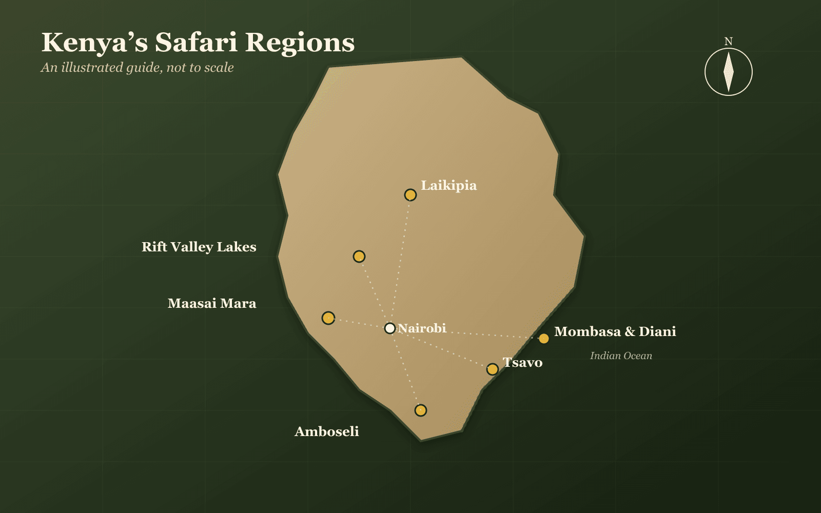
Short answerKenya covers 580,367 km² — roughly the size of France — straddling the equator with the Indian Ocean to the east and the Great Rift Valley running down the middle. The safari parks cluster in three useful places: the south-west (Maasai Mara), the south (Amboseli and Tsavo) and the north (Samburu).
Most Kenya itineraries are presented as a list of park names with no sense of where anything is. This is the geography — which matters, because it determines what can sensibly be combined and what cannot.
The shape of the country
| Detail | |
|---|---|
| Area | 580,367 km² |
| Capital | Nairobi |
| Borders | Somalia, Ethiopia, South Sudan, Uganda, Tanzania |
| Coast | Indian Ocean, to the east |
| Equator | Runs through the middle of the country |
| Administration | 47 counties |
| Highest point | Mount Kenya |
| Defining feature | The Great Rift Valley, running north to south |
The thing to hold on to: Kenya is not flat and it is not uniformly hot. The Rift Valley and the central highlands mean altitude varies enormously, so a country on the equator has genuinely temperate regions — Nairobi included.
Kenya's six safari regions
| Region | Parks | What it's for |
|---|---|---|
| South-west | Maasai Mara and the surrounding conservancies | Big cats, the Great Migration. Against the Tanzanian border. |
| South | Amboseli, Tsavo East, Tsavo West, Chyulu Hills | Elephants, Kilimanjaro views, vast open country |
| Rift Valley | Lake Nakuru, Lake Naivasha, Hell's Gate, Lake Bogoria | Rhino, flamingo, boat trips, walking and cycling |
| Central highlands | Mount Kenya, Ol Pejeta, Aberdares | Rhino conservancy, forest, temperate altitude |
| North | Samburu, Buffalo Springs, Shaba, Meru | Dry-country species found nowhere else in Kenya |
| Coast | Diani, Watamu, Mombasa, Malindi | Beach, usually added after a safari |
The Rift Valley runs down the middle
The Great Rift Valley is the geological feature that explains most of Kenya's variety. A vast trench running north to south, it holds a chain of lakes — Naivasha, Nakuru, Bogoria, Baringo, Turkana — each with a different character and chemistry.
The soda lakes are why Kenya has flamingos in numbers. The freshwater ones support hippo, boat trips and the walking and cycling at Hell's Gate. And the escarpments either side are what make the highlands temperate.
The same rift continues west and north into Uganda as the Albertine Rift, which is where the mountain gorillas live — see the wildlife of Uganda.
The circuits that actually work
| Days | Route |
|---|---|
| 3–4 | Nairobi → fly to the Maasai Mara → fly back |
| 6–7 | Nairobi → Maasai Mara → Amboseli → Nairobi |
| 7–8 | Nairobi → Lake Nakuru → Maasai Mara → Amboseli |
| 10 | Add Samburu in the north, or Tsavo in the south |
| 12–14 | Kenya plus the coast, or Kenya plus gorillas in Uganda or Rwanda |
The Mara is the fixed point in nearly all of them — ~1,510 km² in the far south-west. Everything else is chosen for contrast: Amboseli for elephants and the mountain, Nakuru for rhino and flamingo, Samburu for the dry-country species.
Distances and how people move
Kenya's practical advantage over Uganda is not that it is smaller — it is considerably larger — but that moving around it is easier.
- The airstrip network is dense. Flying between parks is routine and reasonably priced, not a luxury add-on.
- Roads are generally better graded, which is part of why safari minivans are common and costs are lower.
- Nairobi is a genuine hub. Almost every itinerary passes back through it.
- The Nairobi–Mara road transfer is long — most of a day — which is why so many people fly that leg specifically.
The contrast with Uganda is instructive: our Uganda drive times guide shows an 8–10 hour transfer from Entebbe to Bwindi that has no easy road alternative.
Where Kenya sits in East Africa
| Country | Relationship |
|---|---|
| Tanzania | South. Shares the Serengeti–Mara ecosystem and Kilimanjaro's border. |
| Uganda | West. Gorillas and chimpanzees — what Kenya lacks. |
| Rwanda | Beyond Uganda. Gorillas, and the East Africa Tourist Visa applies. |
| Ethiopia, South Sudan, Somalia | North and east. Not safari routes. |
The border with Tanzania is the one that matters most for wildlife. The Maasai Mara and the Serengeti are one ecosystem divided by a line the animals ignore — which is why the Great Migration is a year-round circuit rather than a Kenyan event.
For putting a trip together, see planning a safari in Kenya, and for the people whose land most of the south-west is, the Maasai.
Tell us where you want to go and we will tell you honestly whether the geography supports it.
Kenya's geography: common questions
Where is Kenya? On the east coast of Africa, straddling the equator, bordered by Somalia and the Indian Ocean to the east, Ethiopia and South Sudan to the north, Uganda to the west and Tanzania to the south. It covers 580,367 km² — roughly the size of France.
Where is the Maasai Mara on a map of Kenya? In the far south-west, against the Tanzanian border. It is the northern tip of the Serengeti–Mara ecosystem, which continues south into Tanzania's Serengeti — the animals cross the border freely, which is what makes the Great Migration a single circuit rather than two national events.
How is Kenya divided administratively? Into 47 counties, created by the 2010 constitution. Counties are how Kenyans give directions and how much official information is organised, so they are worth recognising even though safari itineraries are usually described by park rather than county.
What is the Great Rift Valley in Kenya? A vast geological trench running north to south through the middle of the country, holding a chain of lakes including Naivasha, Nakuru, Bogoria and Turkana. It is why Kenya has such varied altitude and climate over short distances, and why the highlands are temperate despite sitting on the equator.
How far is the Maasai Mara from Nairobi? A long road transfer of most of a day, or a short flight to one of several airstrips. Because Kenya's distances are modest by regional standards and its airstrip network is dense, flying between Nairobi and the parks is normal rather than a luxury.
Is Kenya bigger than Uganda? Considerably — Kenya is about 580,000 km² against Uganda's roughly 240,000, so around two and a half times the size. Kenya's parks are further apart in absolute terms but the road and air network is better, so journeys are often quicker.
Sources
- Kenya National Bureau of Statistics — 2019 Kenya Population and Housing CensusAccessed 29 Jul 2026
- Kenya Wildlife Service — Parks and reservesAccessed 29 Jul 2026